Hints and tips to finding the history of your home.
Introduction
Perhaps the most popular enquiries we receive at the archives is related to house history.
This guide will highlight the key collections and sources of information that can help further your research.
The sources can help you find out not only about the history of the building but can also reveal information about those living there. If you would like more information about researching the history of our local residents please see our Researching Family History guide (coming soon).
Maps
The first stop for any building research is our maps. This will give you an idea of the footprint of the building but also can help date when it was built.
In our open access collection we hold Ordnance Survey maps for the local area, dating from the mid-1800s to 1970s. For more information about using the maps please see our How to Find the Right Map research guide (coming soon).
We also hold a selection of historical maps, including plans of parishes and boroughs, as well as maps created by the various local authorities. These are held offsite so please contact us at archives@lbhf.gov.uk for more information.
Top Tip: Names of streets are changed over time, try consulting the Street Index before looking at the maps to see if your street had any previous names.
Photographic collection
Usefully, some of our photographic collection is arranged by location. By using the Subject Index Cards you can look up either the name of building or the street is it located on and find the subject reference. Simply give this reference to the archivist and they will extract what material is available.
For more information on using our Subject Index, or any other index mentioned in this guide, please see our How to use index cards
Case Study
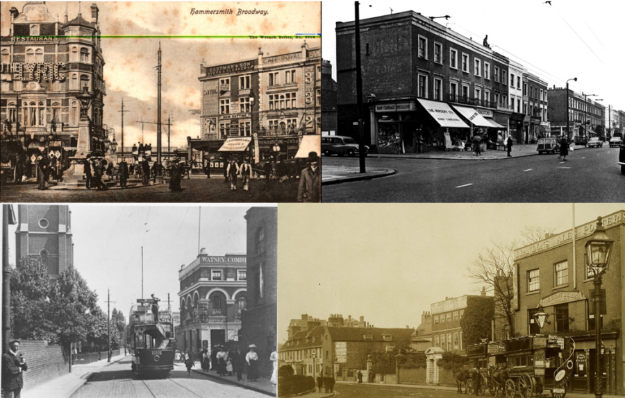
What was there before Hammersmith Broadway Shopping Centre?
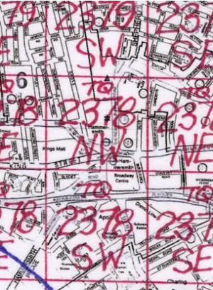
Step 1. Map Index
The Map Index tells me I need to look for maps with the reference X6, TQ 2378 NW or TQ 2378 SW
1894-96 OS Map (X6)
Step 2. OS Maps
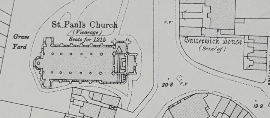
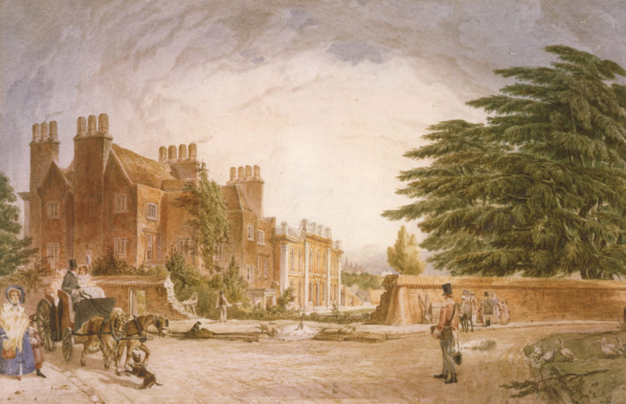
The maps reveal that in the 1920s the site of Butterwick House sat opposite St Paul's Church.
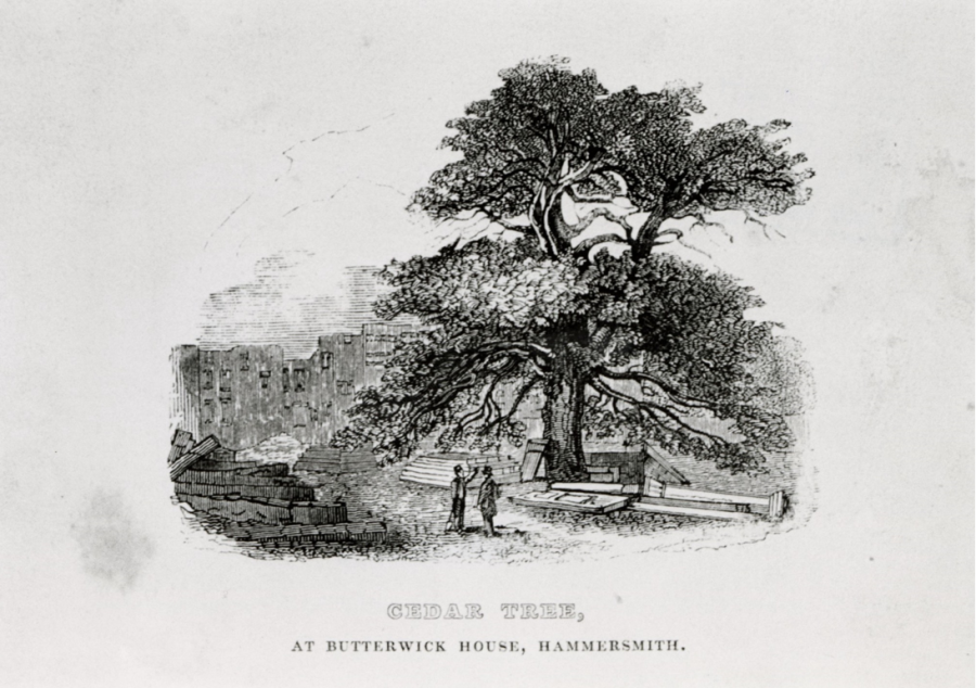
Step 3. Local Studies Collection
The street index points to a folder labelled H728.3 BUT reveals that Butterwick House was also known as Hammersmith House and was famous for its cedar tree. An article in News Sheet (Sep/Oct 1963) gives a brief history:
probably built in the early sixteenth century by Sir William Essex […] the name Butterwick, which has taken on a renewed life by being given to the road which was cut through from Hammersmith Road to enable the Broadway to become a one-way street, comes from John Butterwick or Boterwyk, one of the chief land owners in Hammersmith and Fulham in the fourteenth century.
Electoral Registers
For some researchers it isn't just about the history of the building but about those who lived in them.
Electoral registers give a list of residents that were entitled and had signed up to vote. It is important to note here that it was not until 1884 that all men over 21 could vote, and 1928 that women over 21 could vote.
In our open access collection you can browse the electoral registers from 1880s to 2000s.
Directories
Directories are another useful source of information about the residents but also the purpose of buildings in the bor- ough. In our open access collection we hold directories for the local area dating from the mid-1800s to the mid-1900s.
You can also explore directories online for free via the Uni- versity of Leister: le.ac.uk/library/special-collections/ explore/historical-directories or via Ancestry which can be accessed at all H&F libraries.
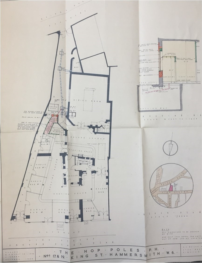
Plans
Our collection holds a selection of plans for the local area. Unfortunately the availability of these plans is not always consistent nor are they in a good enough condition to produce for viewing.
The collection with the widest reach is our drainage plans. The plans were created between the mid-1800s to 1980s when the provision of water and wastewater was transferred from local authorities to private companies. They are useful to house history research as they give an idea of the footprint of the building. While some properties have many plans, others may only have one.
To find out if there are any drainage plans for the building your researching please get in contact with us at archives@lbhf.gov.uk.
Top Tip: You can also search our planning departments records via their online portal: Public Access applications search | LBHF
Online Catalogue
Have you tried searching the name of the building or street in question in our online catalogue?
As part of our archival collections we hold legal documents that were collected and kept as part of the records of organisations, institutions and individuals. These can in- clude property deeds, mortgage transfers and tenant agreements. Archival collections might also hold plans, photographs or even written records recording what life was like living there.
The catalogue will also highlight items within our local studies collections that might be relevant including Conservation Area Profiles and photographs.
To search the catalogue please go to www.apps10.lbhf.gov.uk/archivecat.
For hints and tips about using our catalogue please see our How to... Use Our catalogue guide (coming soon).
Top Tip: Try searching using "" - this tells the database that you are looking for the exact phrase rather than indi- vidual words. This is particularly helpful for streets which have commonly used words in. For example, Edith Street or Fulham Palace Road.
Council records
Some records that might mention the building your researching will not come up in a key word search in the catalogue. Records of H&F Council and its predecessors will hold information on a great number of buildings in the local area. Of particular interest are the following:
First Vestry of Fulham
- Rate Books 1833—1885 (PAF/1/45—245)
- Valuation Lists 1853—1881 (PAF/1/246—260)
- Returns of Street Renumbering 1881—1891(PAF/1/3 30)
Second Vestry of Fulham
- New Streets Apportionment Registers 1886—1903 (PAF/2/94—96)
- Rate Books 1886—1900 (PAF/2/151—351)
- Valuations and Assessments 1885—1909 (PAF//352—375)
- Surveyor's Department and New Streets Case Files and Plans 1885—1938 (PAF/2/376—391)
- Surveyor's Department New Street Files 1869— 1903 (PAF/2/380)
- New Street Plans 1877—1936 (PAF/2/381)
First Vestry of Hammersmith
- Rate Books c.1629—1884 (PAH/1/41—116)
- Surveys and Valuations 1793—1885 (PAH/1/157— 190)
Second Vestry of Hammersmith
- New Streets Letter Books 1886—1902 (PAH/2/93— 101)
- Rate Books 1886—1900 (PAH/103—117)
- Valuation Lists 1886—1904 (PAH/2/118—140)
- Surveyor's Department Records 1886—1900 (PAH/2/186—188)
The following records are not yet browsable on our online cat- alogue. Please contact us at archives@lbhf.gov.uk for more information.
Metropolitan Borough of Hammersmith
- Housing Committee and Subcommittees 1918—1945
Metropolitan Borough of Fulham
- Housing Committee Minutes 1920—1965
London Borough of Hammersmith and Fulham
- Housing Committee and Subcommittees Minutes 1964—2007
Hammersmith & Fulham Archives and Local Studies
H&F Archives and Local Studies
Hammersmith Library Shepherds Bush Road, London W6 7AT
archives@lbhf.gov.uk
020 8753 3850